Less time on-site
less time modeling existing conditions
less time onboarding across offices
Lorem ipsum dolor sit amet, consectetur adipiscing elit, sed do eiusmod tempor incididunt ut labore et dolore magna aliqua. Ut enim ad minim veniam, quis nostrud exercitation ullamco laboris nisi ut aliquip ex ea commodo consequat. Duis aute irure dolor in reprehenderit in voluptate velit esse cillum dolore eu fugiat nulla pariatur.
Block quote
Ordered list
Unordered list
Bold text
Emphasis
Superscript
Subscript
Less time on-site
less time modeling existing conditions
less time onboarding across offices
From floor plans to drone mapping, Polycam makes 3D scanning simple for teams of any size.
Clark Nexsen, an integrated architecture and engineering firm, has long relied on advanced reality capture technologies like terrestrial LiDAR and laser scanners. But deploying specialized scanners and operators for everyday site documentation across project teams created logistical and cost challenges. Looking for a faster way to capture accurate 3D data, Clark Nexsen turned to Polycam and the LiDAR scanning built into their team's iPhones and iPads.
Alexander Ellenbogen, Senior BIM Manager and Senior Architect at Clark Nexsen, explains the limitations they faced with existing high-end scanners. "These systems deliver extensive data, but their complexity and large file sizes create hurdles for routine documentation," Ellenbogen says. "Polycam gives us the accurate spatial data we need through a more accessible and streamlined workflow."
After evaluating mobile scanning options, Clark Nexsen adopted Polycam in early 2024. This put scanning capabilities directly into the hands of their architects and engineers, turning reality capture from a specialized operation into an everyday tool.
Polycam on iPhones and iPads changes how we capture reality. An engineer can walk a site, scan a complex space in minutes, and that 3D data is immediately available to the entire team at any of our offices.
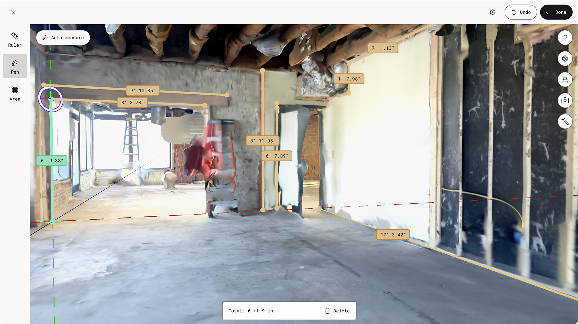
Accelerating Site Capture and Understanding
The impact on fieldwork was immediate. "With Polycam, a team member can take out an iPad or phone, scan a space, and be done," Ellenbogen says.
Using Spatial Capture, their teams now capture comprehensive site data (measurements, equipment locations, structural elements, conditions) with 75 percent less on-site capture time compared to manual methods. The resulting 3D scan becomes a complete spatial record of the space. "It's valuable to bring that building context back to the office," Ellenbogen says. "Designers can virtually navigate the scan anytime, clarify details, or take new measurements without return trips."
Mastering Complex MEP Documentation
Polycam proves valuable for documenting Mechanical, Electrical, and Plumbing (MEP) systems. A single scan captures equipment dimensions, duct and pipe routing, and clearances. This spatial data, captured by the engineer on site, forms the foundation for design decisions.
Integration into Design and Visualization
Polycam data integrates smoothly into Clark Nexsen's design process. Point cloud exports, processed into Revit-compatible formats (RCP or RCS files via Autodesk Recap), link directly into their BIM projects. Designers and engineers then model existing conditions in Revit, referencing the original Polycam scan for verification. "This direct interaction with the captured reality gives us a deeper understanding of the space compared to interpreting 2D notes or photos," Ellenbogen says. This scan-informed modeling speeds up accurate as-built models, reducing time for modeling existing conditions by an estimated 50 percent.
While the scan provides precise data, translating it requires professional judgment. "A scanned wall might be slightly out of plumb, but for design documents, we need to model it perfectly vertical," Ellenbogen says. "Accurate BIM modeling involves interpretation. But starting with Polycam's comprehensive spatial data is far better than relying on manual measurements alone."
The scans also elevate project visualization. Using Enscape, a real-time rendering plugin for Revit, Clark Nexsen incorporates site scans into their models to render proposed designs within captured real-world surroundings. "Using the scan as context saves time modeling terrain, landscaping, and adjacent structures, letting us create accurate renderings faster," Ellenbogen says.
Boosting Collaboration and Client Confidence
As a multi-disciplinary firm with multiple offices, efficient collaboration is key. Polycam Cloud makes this possible. "An engineer can scan a site in Florida, and within minutes, an architect in Virginia Beach can access that 3D scan and begin modeling," Ellenbogen says. This rapid sharing accelerates project startup and simplifies onboarding team members across locations, cutting project onboarding time by roughly 50 percent.
This speed also improves client interactions. "During an initial site walk-through, if a client asks about renovation costs for a specific area or the feasibility of design options, we can do a quick scan," Ellenbogen says. "Using Polycam's measurements, we can provide answers on area takeoffs or spatial constraints almost instantly, boosting client confidence."
This proved valuable on a full-gut office renovation in Raleigh where no existing drawings were available. After interior demolition exposed the structure, one team member scanned the space with Polycam. "That scan gave us accurate structural dimensions, letting our engineer in Charlotte perform analysis remotely and providing the geometry needed to understand what interventions were possible," Ellenbogen says. "Getting that level of documentation from one site visit, by one person, was a massive efficiency gain."
Embracing Future Efficiencies
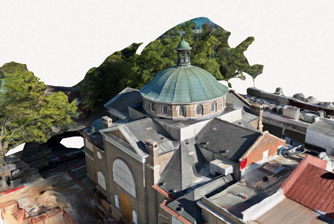
Beyond handheld use, Clark Nexsen has evaluated Polycam Drone Mapping. By uploading aerial photos from a drone mission documenting hurricane damage, they found Polycam produced detailed results, validating its capabilities as another tool in their reality capture toolkit.
Clark Nexsen continues exploring ways to optimize workflows. They are monitoring Autodesk's work on improving the connection between Recap point cloud processing and Revit object creation. "We're interested in developments that could streamline classifying point cloud elements, like identifying points as walls or pipes within Recap, and making the conversion to native Revit objects smoother," Ellenbogen says. "Tools that enhance our Autodesk ecosystem and make scan-to-BIM more seamless are always a priority."
The firm is also considering digital handover requirements, including contractor-provided Polycam scans during construction verification, especially before in-wall utilities are concealed behind finishes. "Clients increasingly want detailed as-built information for long-term facilities management," Ellenbogen says. "Requiring a verification scan before close-out provides a permanent record of what's inside the walls. It's a logical next step in delivering comprehensive project documentation."
For Clark Nexsen, Polycam bridges the gap between the real world and the demands of digital design and collaboration. "Polycam on iPhones and iPads changes how we capture reality," Ellenbogen says. "An engineer can walk a site, scan a complex space in minutes, and that 3D data is immediately available to the entire team at any of our offices. It makes reality capture practical for everyday architectural and engineering work.
Lorem ipsum dolor sit amet, consectetur adipiscing elit, sed do eiusmod tempor incididunt ut labore et dolore magna aliqua. Ut enim ad minim veniam, quis nostrud exercitation ullamco laboris nisi ut aliquip ex ea commodo consequat. Duis aute irure dolor in reprehenderit in voluptate velit esse cillum dolore eu fugiat nulla pariatur.
Block quote
Superscript
Bold text
Emphasis
Subscript
From floor plans to drone mapping, Polycam makes 3D scanning simple for teams of any size.

Lorem ipsum dolor sit amet, consectetur adipiscing elit, sed do eiusmod tempor.


